
Peru Facts & Figures include detailed numbers, data, and stats, as well as lots of useful information about Peru related to the following topics: Geography of Peru, Peruvian government & administration, Peru's national symbols, Peruvian economy, People of Peru, Health in Peru, Education in Peru, Infrastructure & Transport in Peru.
Content Overview
- General Information about Peru
- Geography of Peru
- Peruvian government & administrative divisions
- Peru's national symbols
- Peruvian economy
- People of Peru
- Health in Peru
- Education in Peru
- Infrastructure & transport in Peru
- Facts & Figures about Lima
1 General Information about Peru
Peru, officially the Republic of Peru, is located in western South America. The country borders in the north on Ecuador and Colombia, in the east on Brazil and Bolivia, in the south on Chile and in the west on the Pacific Ocean.
Peru is the third largest country in South America after Brazil and Argentina, and the 19th largest in the world.
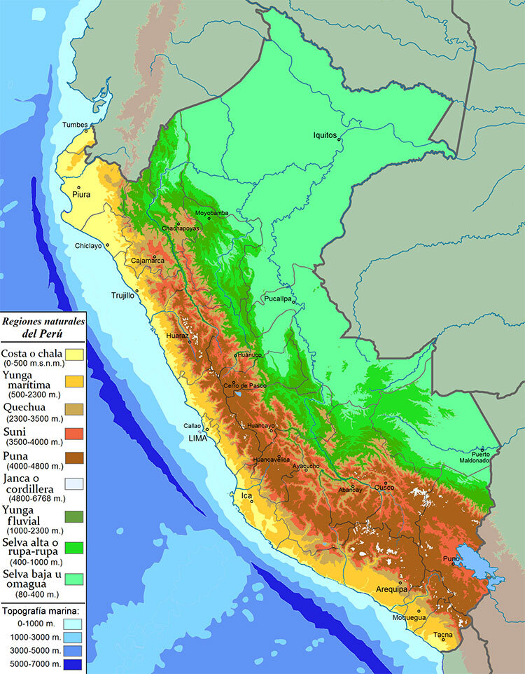
The Peruvian territory covers an area of 1,285,216 square kilometers (496,225 square miles) and is geographically divided into three zones: the coast (costa): the western coastal plain with deserts, beaches and fertile valleys; the mountain region (sierra): the mountainous area dominated by the Andes that crosses the country in north-south-direction; and the jungle (selva): the eastern lowland jungle of the Amazon basin.
Even though the coastal region only accounts for about 11% of the Peruvian territory, more than half of the population (60.9%) lives in this area. The Andean region, however, is home to 25% of the population, whereas only 14.1% of Peruvians live in the lowland jungle.
Lima is the capital of Peru, while the neighboring, independent city of Callao, with its busy port and Jorge Chavez International airport, is the country’s gateway to the world.
Peruvian Currency
Since 1991 the Peruvian currency is the “Nuevo Sol” (S/.), which was renamed to just “Sol” (S/) in 2016 - plural (Nuevos) Soles. Its international code is PEN. There are banknotes for S/ 10, S/ 20, S/ 50, S/ 100 and S/ 200. Current coins include 10, 20 and 50 centimos as well as 1 Sol, 2 Soles and 5 Soles. The 1 centimo coins initially issued in 1991 and following years were removed from circulation in 2011 and the 5 centimos coins in 2019.
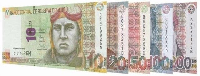
Current Peruvian Banknotes
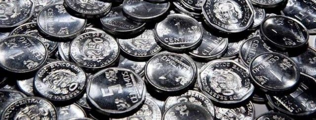
Current Peruvian Coins
Time zone in Peru
GMT -5
Telephone dialling code for Peru
+ (51)
Web page / internet abbreviation for Peru
.pe / .com.pe
Electricity in Peru
230V / 60Hz
Climate & Weather in Peru
Generally Peru’s climate is:
- Arid and mild in the coastal area
- Temperate to frigid in the Andean highlands
- Warm and humid in the jungle lowlands
You find a more detailed description about the Peruvian climate in our article "Weather and Climate in Peru".
The Weather and Climate in Peru
Flora and fauna of Peru
- Peru is home to 84 of the world's 103 ecosystems
- The country is among the five most important centers in the world for genetic resources of plants and animals
2 Geography of Peru
Location of Peru
Western South America at the Pacific Ocean
Neighboring countries of Peru
- North: Ecuador (border of 1420 km) and Colombia (border of 1800 km)
- East: Brazil (border of 2995 km) and Bolivia (border of 1075 km)
- South: Chile (border of 171km)
- West: Pacific Ocean (coastline of 2414 km)
Peru's surface area
- Total: 1,285,216 km² (496,224.5 sq mi)
- Land: 99.6%
- Water: 0.4%
Peruvian terrain types
- 11.7% Costa - Western coastal plain with deserts, beautiful beaches and fertile valleys
- 28.4% Sierra - Mountainous area dominated by the Andes that runs through the country in north-south direction
- 59.9% Selva - Eastern lowland jungle of the Amazon basin
Elevation extremes in Peru
- Lowest point: Bayóvar Depression -34 m (-112ft)
- Highest point: Nevado Huascaran 6,768 m (22,205 ft)
Longest rivers in Peru
- Rio Ucayali 1,771 km (1100 miles)
- Rio Marañón 1,414 km (879 miles)
- Rio Putumayo 1,380 km (858 miles)
- Rio Yavarí 1,184 km (736 miles)
- Rio Huallaga 1,136 km (707 miles)
- Rio Urubamba 862 km (536 miles)
- Rio Mantaro 724 km (450 miles
- Rio Amazon 713 km (443 miles)
Lakes in Peru
Peru has more than 12,000 lakes and lagoons that were created by glaciers and tectonic movements. Most lakes are on the eastern slopes of the Andes mountains.
The largest lake in Peru is Lake Titicaca in southern Peru bordering Bolivia. It covers 36,180 hectares (89,403 acres). With a surface elevation of 3,812 m (12,507 ft) it’s the highest navigable lake in the world and additionally by surface area and volume the largest lake in South America.
The second largest lake is Lake Junin, followed by the Arapa Lagoon.
Tallest waterfalls in Peru
- Tres Hermanas (three sisters) waterfall in the Junin region with 914 m (3,000 ft)
- Yumbilla waterfall in the Amazonas region with 896 m (2,938 ft)
- Gocta waterfall in the Amazonas region with 771 m (2,531ft)
Land use in Peru (estimates 2020)
- Forest: 56.5%
- Agricultural land: 19.1%
- Other: 24.4
Natural hazards in Peru
- Earthquakes
- Tsunamis
- Flooding
- Landslides
- Mild volcanic activity
3 Peruvian government & administrative divisions
Official country name of Peru
República del Perú (Republic of Peru)
Form of government in Peru
Constitutional Republic
Capital of Peru
Lima
Independence of Peru
28th July 1821 (from Spain)
Peruvian constitution
Latest December 29, 1993 (last amended 2015)
Legal System in Peru
Based on a civil law system
Executive branch
- Chief of state: President Dina Boluarte (since December 2022)
- Head of government: President Dina Boluarte (since December 2022)
- Cabinet: Council of Ministers appointed by the president and led by the Prime Minister
- Elections: President elected by popular vote for 5 years
Legislative branch
- Unicameral Congress of the Republic of Peru with 130 seats.
- Members are elected by popular vote for a five-year term
Judicial branch
Supreme Court of Justice. Judges are appointed by the National Council of the Judiciary
Find more detailed information
Politics of Peru
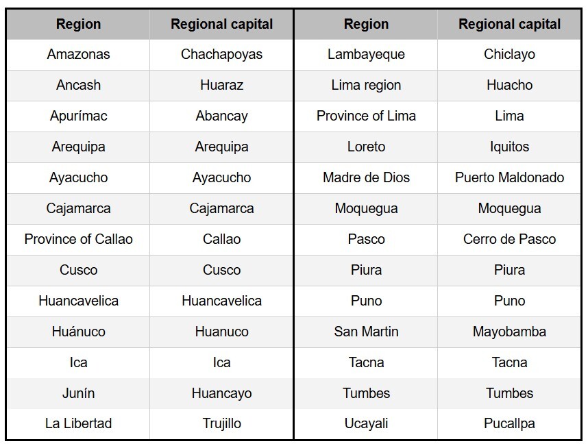
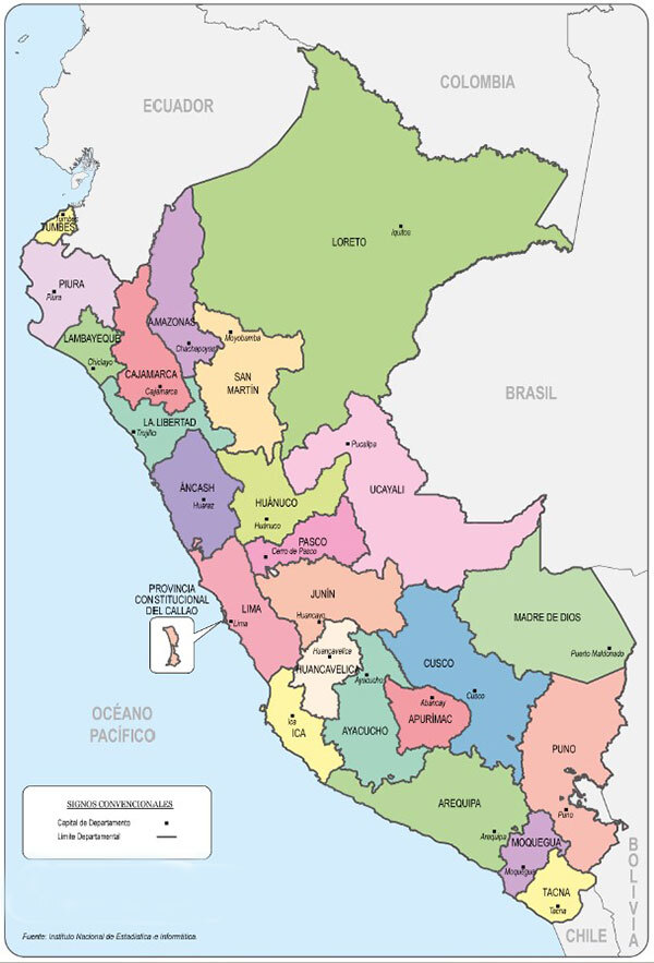
Regions of Peru
Peru is divided into 24 regions (“departmentos”) and 2 autonomus provinces (Lima and Callao). Each region is subdivided into provinces (provincias), which are further subdivided into districts (distritos).The regions of Peru are in alphabetical order:
Main Peruvian cities (projected population 2022; source: INEI)
- Lima Metropolitana: 11.09 million citizens (Lima 9,943,800 and Callao 1,154,200)
- Arequipa: 1,142,900 citizens
- Trujillo: 1,111,300 citizens
- Chiclayo: 825,760 citizens
- Piura: 760,500 citizens
- Huancayo: 560,200 citizens
- Cusco: 535,300 citizens
- Iquitos: 485,200 citizens
- Pucallpa: 415,800 citizens
- Chimbote: 412,600 citizens
- Ica: 348,100 citizens
- Tacna: 377,500 citizens
- Juliaca: 358,700 citizens
- Ayacucho: 270,300 citizens
- Cajamarca: 268,800 citizens
4 Peru’s national symbols
Peru’s National Anthem - Himno Nacional del Perú
Peru’s national anthem was composed by José Bernardo Alcedo shortly after the Peruvian independence. While since then the lyrics of the “Marcha Nacional” (the National March) were rewritten several times, they tell the story of a proud and free nation.

National Anthem of Peru - Himno Nacional del Perú
Peru’s National Flags & Coat of Arms
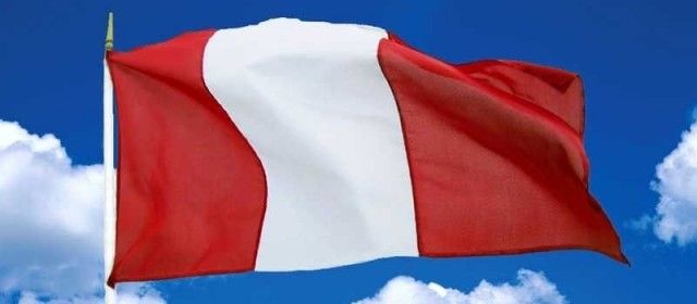
- Peru’s national flag is the “Bandera Nacional”. It has three equal, vertical bands in red, white and red. The red symbolizes the bloodshed during the struggle for Peru's independence and the bravery of the men fighting for freedom, while the white stands for peace and justice.
- The Peruvian state flag, called “Pabellón Nacional”, is only used during official state businesses or by Peruvian state institutions. It has the same tri-band red and white stripes as the National Flag; but includes in the central white band includes the Peruvian Coat of Arms, the so called “Escudo de Armas”.
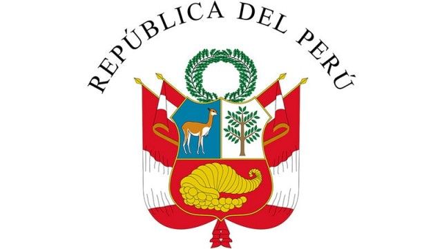
- The Peruvian Coat of Arms consists of the national shield (the Escudo Nacional) which features a vicuña (Peru's national animal) on the upper left, a chinchona tree (native to the tropical Andes region and the source for the anti-malaria drug quinine) on the upper right and a cornucopia filled with coins on the bottom. These images represent Peru's fauna, flora and mineral wealth. The shield is topped with a Holm oak Civic Crown and surrounded by a palm branch on the left and a laurel branch on the right that are tied together with a red and white ribbon.
- The war flag of Peru is the Bandera De Guerra. Used only by the Armed Forces and National Police the war flag has the same tri-band red and white stripes as the national flag and the state flag, but includes in the central white band the national shield flanked by Peruvian flags instead of the palm and laurel branches used on the state flag.
The History of the Peruvian National Flag
Peru’s “unofficial” national symbols
- National colors of Peru: Red and white
- National animal of Peru: Vicuña
- National bird of Peru: Andean Cock-of-the-rock
- National tree of Peru: Cinchona (Quinine bark)
- National flower of Peru: Cantua, also known as Sacred flower of the Incas
- National instrument of Peru: Pan flute and cajón
- National drinks of Peru: Pisco Sour and Inka Cola
- National dish of Peru: Ceviche
- Logo of Peru: Marca Peru (Peru brand)
5 Peruvian economy
Peruvian economy - World positioning
The Peruvian economy is the 49th largest in the world and is classified by the World Bank as upper middle income.
GDP in Peru 2022
- GDP: US$ 242.63 billion (source: Worldbank)
- GDP annual variation: 2.7% (source: INEI)
- GDP per capita: US$ 7,330 (source: BCRP)
- GDP (PPP) total: US$$ 512.36 billion (source: Worldbank)
- GDP (PPP) per capita: US$ 15,679 (source: BCRP)
GDP by sector in 2022 (source: INEI)
- Manufacture: 16.5%
- Mining and Hydrocarbons: 14.4%
- Commerce: 10.2%
- Agriculture: 5.9%
- Construction: 5.1%
- Transport & courier service: 5.0%
- Public administration: 4.3%
- Services provided to companies: 4.2%
- Finances and insurances: 3.2%
- Hospitality: 2.9%
- Telecommunications: 2.7%
- Electricity and water: 1.7%
- Fishery: 0.7%
- Other services: 14.9%
- Import duties and product taxes: 8.3%
Inflation Rate in Peru 2022 (source: INEI)
- Inflation rate: 8.5%
Peruvian net international reserves (source: BCRP)
2022: 29.4% of the GDP
June 2023: US$74.479 billion
Labor and employment in Peru (source: INEI)
- Working age population 2022: 25.62 million
- Economically active population nation 2022: 18.55 million (72.4% of working age population)
- Unemployment rate 2022 nation: 4.3%
- Underemployment rate 2022 nation: 47.8%
- Adequate employment rate 2022 nation: 52.5%
- Formal employment 2022: 24.3%
- Informal employment 2022: 75.7%
- Informal employment urban areas 2022: 70.5%
- Informal employment rural areas 2022: 95.3%
- Minimum wage since May 2022: S/ 1025 per month
- Average monthly income nation 2022: S/ 1,453
Poverty in Peru 2022 (source: INEI)
- Poverty rate nation : 27.5%
- Extreme poverty rate: 5.0%
Natural resources in Peru
Copper, silver, gold, petroleum, timber, fish, iron ore, coal, phosphate, potash, natural gas, hydro-power
Industries in Peru
Mining and refining of minerals, steel, metal fabrication, petroleum extraction and refining, natural gas, fishing and fish processing, textiles, clothing, food processing.
Agriculture in Peru
Asparagus, coffee, cocoa, cotton, sugarcane, rice, potatoes, corn, plantains, grapes, oranges, pineapples, guavas, bananas, apples, lemons, pears, coca, tomatoes, mangos, barley, medicinal plants, palm oil, marigold, onions, wheat, dry beans; poultry, beef, dairy products, fish, guinea pigs.
Exports from Peru 2022
- Total value of exports 2022: US$ 63,193 million (source: Mincetur)
- 4,953 products were exported to 168 countries (source: Mincetur)
- Major exported products:ores, precious metals, mineral fuels, mineral oils and products of their destillation, fruits and nuts, copper, animal feed (mainly fish meal), coffee, tea and spices, clothing, seafood, zinc and its products
- Major export partners 2022: China (32.9%), USA (13.6%), Japan (4.9%), Souht Korea (4.3%), Canada (4.2%)
Imports to Peru 2022
- Total value of imports 2022: US$ 54,583 million (source: Mincetur)
- 4,450 products were imported from around the globe (source: Mincetur)
- Major imported products: mineral fuels and oils, industrial machinery, vehicles and parts, electrical machinery, cast iron, iron and steel, plastics, grains, products for the chemical industry, fertilizer, pharmaceutical products
- Major import partners 2022: China (26.2%), USA (23.6%), Brazil (7.0%), Argentina (5.1%), Mexico (3.3%)
For a more detailed insight into the Peruvian economy including lots of graphs check out our article "Peruvian economy".
Peruvian Economy
6 People of Peru
Population in Peru 2022 (source: INEI)
- Population: 33,396,700
- 49.6% men; 50.4% women
- Population density (2021): 26 persons per km² (67 persons per square mile)
- Population growth: 1.09%

Development of the Peruvian population from 1836 to 2022; data for 1836 till 2017 from Censuses 1836, 1850, 1862, 1876, 1940, 1961, 1972, 1981, 1993, 2005, 2007 and 2017; data for 2021 and 2022 as published by INEI
Population distribution in Peru 2022 (source: INEI)
- Coast (costa): 60.9%
- Highlands (sierra): 25.0%
- Amazonian lowlands (selva): 14.1%
- Urban areas: 79.8%
- Rural areas: 20.2%
Age distribution in Peru 2022 (source: INEI)
- 0-14 years: 24.3%
- 15-59 years: 62.4%
- 60+ years: 13.3%
- Average age 2022: 33.4 years
Detailed age distribution in Peru 2022 (source: CPI Research)
- 0-5 years: 9.9%
- 6-12 years: 11.2%
- 13-17 years: 7.9%
- 18-24 years: 10.9%
- 25-39 years: 23.4%
- 40-55 years: 19.6%
- 56 years and over: 17.1%
Population pyramid of Peru 2022

Ethnic groups in Peru (source INEI: data from census 2017)
In the 2017 population census, Peruvians were asked to ethnically identify themselves for the first time. Below numbers are the results of this self-identification.
- 60.2% Mestizo (mixed native American and white)
- 22.3% Quechua
- 5.9% White
- 3.6% Afro-Peruvians
- 2.4% Aymara
- 5.6% indigenous or natives from the Amazonian lowlands, Nikkei (Japanese-Peruvian), Tusan (Chinese-Peruvian) and others
Languages in Peru (source: INEI; data from census 2017)
- Spanish (official) spoken by 82.6% of the population
- Quechua (official) spoken by 13.9% of the population
- Aymara (official) spoken by 1.7% of the population
- A large number of indigenous Amazonian languages spoken by 0.8% of the population
- Other foreign languages spoken by 0.2% of the population
Religions in Peru (source: INEI; data from census 2017)
- 76% Roman Catholics
- 14.1% Evangelical Protestants
- 4.8% others
- 5.1% none
Demonym
Peruvians are called Peruano(s) (m) or Peruana(s) (f).
7 Health in Peru
- Life expectancy of the total population in Peru 2021 (Worldbank): 72 years; 2020: 74 years, 2019: 76 years
- Life expectancy of men 2021: 70 years
- Life expectancy of women 2021: 75 years
- Birth rate in Peru 2023 (source: World Factbook).: est. 16.96 births / 1000 citizens
- Death rate in Peru 2023 (source: World Factbook): est.11.04 deaths / 1000 citizens
- Infant mortality rate in Peru 2023 (source: World Factbook): est. 10.8 deaths / 1000 live births
- Fertility rate in Peru 2022 (source: INEI): 1.9 live births per woman; 1.7 in urban areas, 2.8 in rural areas
- Mean age of Peruvian women at birth of first child 2022 (source: INEI): 22.2 years
- Rate of teenage pregnancy in Peru 2022 (source: INEI): 2.7% of Peruvian girls age 12-17 years were pregnant; 2.0% are mothers
- Population with chronic diseases in Peru Jan-Mar 2023 (source: INEI): 40.4%
- 42.4% in urban areas 35.8%; 32.5% in rural areas
- Population with a calorie deficit Jan-Mar 2023 (source: INEI): 35.4%
- Lima metropolitan area 40.7%; urband areas: 32.9%; rural areas: 32.3%
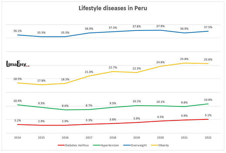
- Diseases of civilation in Peru
- Rate of anemia in children in Peru 2022 (INEI)
- age 6 to 35 months: 42.4% (2021:38.8%); in urban areas: 39.0%, in rural areas: 51.5%
- age 6 to 59 months: 33.6% (2021: 28.4%); in urban areas: 30.3%, in rural areas: 42.4%
- Chronic malnutrition in children under 5 years in Peru 2022 (INEI): 11.7%
- In urban areas: 7.1%; in rural areas: 23.9%
- Coastal areas: 5.7%; highlands: 18.9%; jungle: 17.1%
- Population with health insurance in Peru nation Jan-Mar 2023 (source: INEI): 86.7%
- 57.8% of the Peruvian population has SIS (Seguro Integral de Salud)
- 23.9% of the Peruvian population has EsSalud
- 5.0% of the Peruvian population has other health insurances (private, military, police)
- 13.3% of the Peruvian population has no health insurance
- Population with health insurance in urban areas in Peru Jan-Mar 2023 (source: INEI): 85.5%;
- 51.0% of the population in urban areas has SIS (Seguro Integral de Salud)
- 28.5% of the population in urban areas has EsSalud
- 6.0% of the population in urban areas has other health insurances (private, military, police)
- 14.5% of the population in urban areas has no health insurance
- Population with health insurance in rural areas in Peru Jan-Mar 2023 (source: INEI): 91.3%;
- 85.6% of the population in rural areas has SIS (Seguro Integral de Salud)
- 5.4% of the population in rural areas has EsSalud
- 0.3% of the population in rural areas has other health insurances (private, military, police)
- 8.7% of the population in rural areas has no health insurance
- Population with any kind of disability in Peru 2020 (source: INEI): 10.3%
- from these 48.3% are visually impaired
- 15.1% have difficulties walking
- 7.6% are hearing impaired
- 4.2% have learning difficulties
- 3.1% are speech impaired
- Major Infectious Diseases in Peru
- Food or waterborne diseases: Bacterial diarrhea, hepatitis A and typhoid fever
- Vector borne diseases: Dengue fever and Oroya fever
8 Education in Peru (source: INEI)
- Illiteracy rate 2022: 5.2% of the Peruvian population age 15 and older cannot read and write
- 3.1% of the Peruvian population age 15 and older, whose first language is Spanish cannot read and write
- 13.8% of the Peruvian population age 15 and older, whose first language is a native language, cannot read and write
- Mean years of schooling in Peru 2022:
- males: 10.1 years
- females: 9.3 years
- urban areas: 10.3 years (males) and 10.2 years (females)
- rural areas: 5.7 yeas (males) and 5.0 years (females)

- Public school: 76% of Peru's students attend public schools (2021)
- Private school: 24% of Peruvian students attend private school (2021)
- No education: 4.4% of the Peruvian adult population has no formal education
- Primary education: 24.8% of the Peruvian adult population has a primary education
- Secundary education: 40.8% of the Peruvian adult population has a secondary education
- Tertiary education (no university): 14.8% of the Peruvian adult population has a tertiary education (no university)
- University education: 15.2% of the Peruvian adult population has a university education
- Education expenditures 2021: 4% of GDP (World Bank)
9 Infrastructure & transport in Peru
Access to basic infrastructure in Peru 2022 (source: INEI)
- water: 77.9% of Peruvian households are connected to the public water supply
- 79% in urban areas, 74% in rural areas
- wastewater: 71.8% of Peruvian households are connected to the public wastewater system
- 85.8% in urban areas, 22.5% in rural areas
- electricity: 96.2% of Peruvian households are connected to electricity
- 98.8% in urban areas, 87.2% in rural areas
Consumer goods and communication in Peruvian households

Airports in Peru
Peru has over 200 airports and airstrips from which only 27 have scheduled services: 5 international airports and 22 national airports.
International Airports in Peru
- Lima / Callao: Jorge Chávez International Airport
- Arequipa: Rodríguez Ballón International Airport
- Chiclayo: FAP Captain José Abelardo Quiñones González International Airport
- Cusco: Alejandro Velasco Astete International Airport
- Trujillo: Cap. FAP Carlos Martínez de Pinillos International Airport
Domestic Airports in Peru
- Andahuaylas: Andahuaylas Airport
- Atalaya: Tnte. Gral. Gerardo Pérez Pinedo Airport
- Ayacucho: FAP Coronel Alfredo Mendívil Duarte Airport
- Cajamarca: FAP Mayor General Armando Revoredo Iglesias Airport
- Chachapoyas: Chachapoyas Airport
- Huánuco: FAP David Figueroa Fernandini Airport
- Huaraz: FAP Commander Germán Arias Graziani
- Ilo: Ilo Airport
- Iquitos: FAP Coronel Francisco Secada Vignetta International Airport
- Jaén: Jaén Airport
- Jauja: Francisco Carlé Airport
- Juliaca: Inca Manco Cápac International Airport
- Piura: FAP Captain Guillermo Concha Iberico International Airport
- Pucallpa: FAP Captain David Abensur Rengifo International Airport
- Puerto Maldonado: Padre Aldamiz International Airport
- Punta Sal: Walter Braedt Segu Aerodrome
- Tacna: FAP Coronel Carlos Ciriani Santa Rosa International Airport
- Talara: FAP Captain Victor Montes Arias Airport
- Tarapoto: FAP Cadet Guillermo del Castillo Paredes Airport
- Tingo María: Tingo María Airport
- Tumbes: FAP Captain Pedro Canga Rodríguez Airport
- Yurimaguas: Moisés Benzaquen Rengifo Airport
Military Airports in Peru
- Lima: Las Palmas Air Base
- Arequipa: Mariano Melgar Air Base, La Joya
- Ica: San Juan de Marcona Aerodrome
- Iquitos: Teniente Bergerie Airport
- Talara: El Pato Air Base
Ports in Peru
Peru has over 100 ports which are classified as sea, river and lake ports.
Main seaports
- Callao: the country's main cargo and container port as well as the most important container transhipment port on the west coast of South America
- Paita
- Matarani
- Talara
- Salaverry
- Ilo
- Chimbote
- San Martin (Pisco)
Main river ports
- Iquitos
- Pucallpa
- Yurimaguas
Railways in Peru (source: World Factbook 2017)
- 1,854.4 km of railway tracks in Peru (1152.27 Miles)
- 1730.4 km with standard gauge (1074.97 Miles)
- 124 km with narrow gauge (77.05 Miles)
Roads in Peru (source: MTC 2021)
Peru has about 175,000 km (109,000 miles) of roads and tracks.
- about 30,000km (18,700 miles) are national roads; from which 79.1% are paved
- about 25,000km (15,500 miles) are departmental (secundary) roads, from which only 13.2% are paved
- 120,000km (75,000 miles) local roads, from which less than 2.0% are paved
Waterways in Peru
8808 km (5,500 miles) of waterways in Peru
Facts & Figures about Lima
For detailed numbers, data, and stats, as well as lots of useful information about Lima check out our extensive "Important Facts and Figures about Lima"
Important Facts and Figures about Lima


")


")


")


