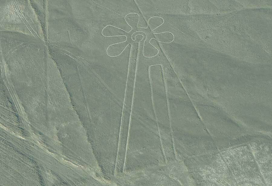
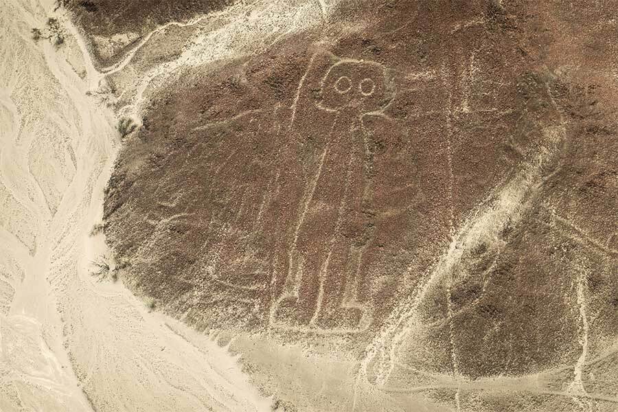
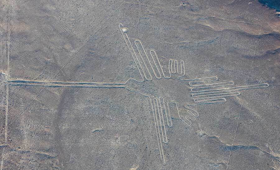
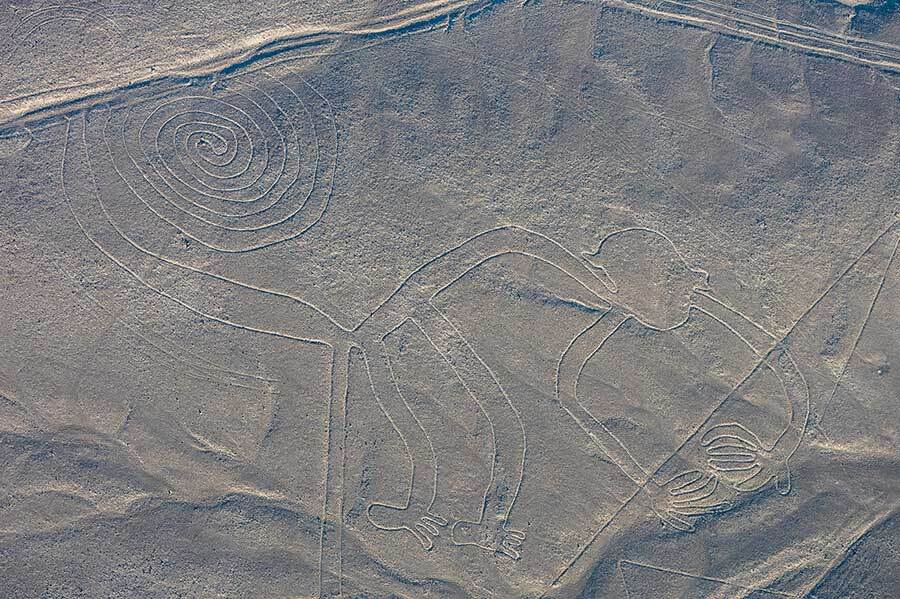
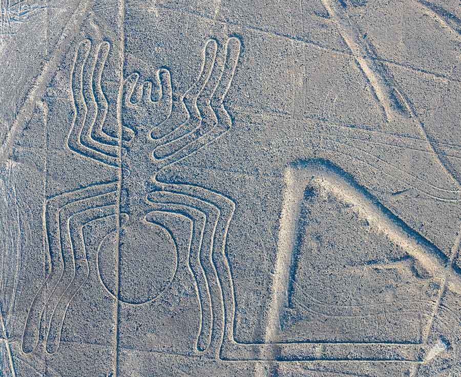
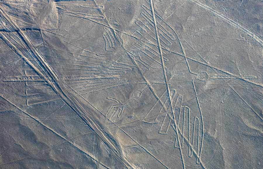
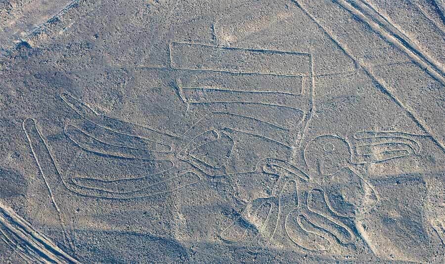
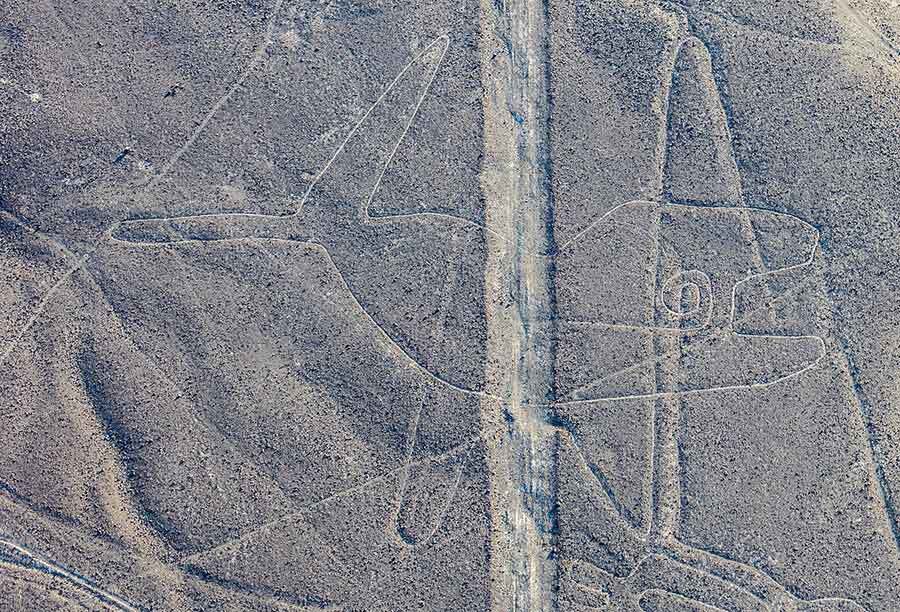
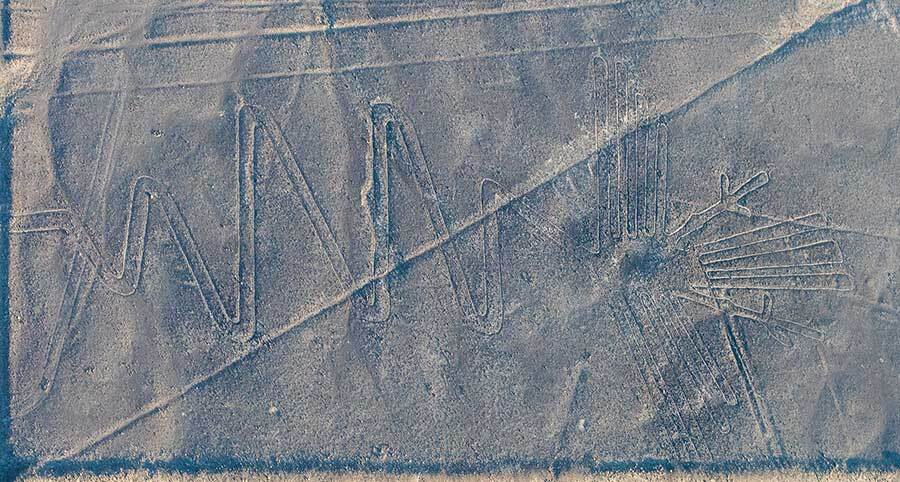
1 Comment
The Mystery of the Nazca Lines

The Mystery of the Nazca Lines in Peru

Gigantic Sand Drawings in the Desert of Southern Peru

In the 1920s, when people first flew across southern Peru, they made an astonishing discovery. Stretching below them, written on the earth of this remote desert region, were thousands of gigantic drawings: animals, insects and birds; long, long straight lines and odd geometric shapes.

How long had the drawings been there, unremarked, in this remote desert? Who could have drawn such gigantic pictures? How were they able to draw, with such precision, images that can only really be appreciated from the sky? And - the most intriguing question of all - why on earth did they do it?

In the far south-western corner of Peru, 400 kilometers (250 miles) from the capital, Lima, is a high plateau called the Nazca pampa. Bounded by a narrow fertile strip that hugs the Pacific coast on one side, and by the towering snowcapped Andes on the other, this is one of the most desolate landscapes on earth.

The Nazca Lines Plateau in Peru

From the air, the land is beige and brown, scarred and crumpled, cut through by deep river gorges and riven by a mass of dried-up stream beds. It is arid and forbidding from a distance and, on the ground, it is dusty, hot and monotonous. There is no vegetation of any kind here. No birds call. No insects buzz. The silence is absolute. It is rarely windy and there are not even any clouds in the sky to vary the light and cause a shadow to move across the land. On the rare occasions when people are walking on the pampa, they can clearly hear each other call from half a kilometer away. It almost never rains on the pampa; the official tally is 0.5 mm (0.02 inches) of rain per year. And the air is so dry that the mark of raindrops of a shower that fell briefly four years ago are still there, marking the dust on rocks with strangely tragic splashes.

Yet this remote and almost unpopulated desert holds a secret. For a person walking across this bare and dusty land would find - scattered as if carelessly across the sterile wasteland - the most unexpected and extraordinary evidence of an ancient and vanished civilization. There are fragments of chunky pottery, deco­rated in bright colors with stylized images of birds and mythical creatures. There are ruins of buildings, some made of stone, others made of adobe bricks and now almost indistinguishable from the reddish brown of the desert earth itself. There are strange small mounds - surely man-made - and stone tombs. Most extraordinary of all, there are skeletons - bleached snowy white by the sun, curled in a fetal position and wrapped in pieces of dark-colored woven cloth, their skulls gleaming in the bright sunlight.

Who were these people? When did they live on the Nazca plateau? And how did they survive to build a life in such a dry land?

And there is something stranger still about this desert land, a mystery that can only really be appreciated from the air and that only emerged in the late 1920s when planes first flew across this remote region of Peru. Looking down from their cockpits, these early twentieth-century pilots had for the first time a bird's-eye view of this desert. And what they saw was astonishing. Spread across the desert, over an area around 500 square kilometers (311 square miles), were thousands of enormous line drawings.

Some are in the shape of living things: birds, monkeys, lizards and a whale. There are plants and fishes too. Some images, like the hummingbird, for instance, are realistic and easily identified. Others can be identified as local South American species, but they have been drawn with mystifying mistakes or deliberate inaccuracies. The monkey, with its front paws pointing inwards and arched back, for instance, has a great curling tail like the South American spider monkey, but the tail curls the other way from that of a real monkey. Other drawings are highly stylized - like the carob tree with its symmetrical pattern of roots and branches; or the magnificent bird figure, with its elongated zigzag neck that immediately conjures up the sight of a sleek black cormorant dropping like a stone towards the sea. Some figures are imaginary composite creatures, part bird, part insect, and others just defy definition.

The Nazca Lines in Peru

But, as you fly over this barren landscape, the ordinariest “lines” to be seen are the geometric shapes. There are spirals and zigzags. There are the blunt triangles that the experts called trapezoids. And there are long, long straight lines, some leading like the spokes of a wheel back to some central point, usually a small mound; others simply heading out across the land, disappearing into the shimmering distance.

Most of the drawings are enormous: the hummingbird is 90 meters (295 feet) long. The condor has a wingspan of 137 meters (450 feet) and the largest of the trapezoids covers 100 square kilometers (62 square miles). And two generations after the pilots who first saw the Nazca Lines, they discovered that the long straight lines - the longest of which stretches unbroken for 65 kilometers (40 miles) - can even be seen from space.

Overlapping and crisscrossing as they do, it is impossible to be sure exactly how many lines there are. One small area of plateau has over 900 of them. But one local pilot, who has been overflying the lines and photographing them for over 40 years, estimates that the total number is over 3,000.

In the 1930s, as aerial photographers, archaeologists, journalists and travelers descended on Nazca to see the lines for themselves and seek to unravel their mysterious origins, the first question they asked was, how did the line builders make them in the first place? From the air, the making of these geoglyphs seems an extraordinary undertaking. But down on the desert floor, the technique turns out to be less of a mystery. To make a Nazca Line is in fact quite simple. The surface of the pampa is covered with a coarse layer of rocks, stone and gravel called desert pavement; the remains of rocks carried down from the Andes by floods hundreds of thousands of years ago. Over the centuries, exposure to the air has darkened the surface of this desert pavement, so the ground is naturally of a dark grey brown color. But remove these darker rocks with their patina of time, and a tremendous contrast is revealed: the sand beneath is much lighter-colored, more of a cream than a brown. The line builders simply had to remove one layer of rock systematically to make their great pale-colored pictures. It would not have required any tools more sophisticated than baskets to transport the stones.

nazca lines peru the flower
Nazca Line in Peru - "The Flower"

But what is so impressive about the lines is not the fact that someone worked out that by removing a layer of stones from the desert, enormous pictures could be made. After all, figures like England’s Uffington White Horse were made many centuries ago by removing turf in a certain shape to reveal the gleaming white chalk beneath. What impressed explorers to Nazca was the fact that the drawings appear to be so symmetrical and perfectly made, despite being both so large and sometimes so complicated. Surely, people reasoned, it would have been impossible for the line builders to achieve such precision unless (like present-day visitors) they could see their creation from the air.

People were also bemused why anyone would go to the immense trouble of building these gigantic pictures when they can only really be seen from the air. In the late 1960s, Swiss author Erich von Daniken came to Nazca and declared that he had the answer. Looking down at the long, rounded triangles and the trapezoids from a small plane, he saw only one purpose and one explanation: they had been built as landing strips for spacecrafts. And the line builders must have been aliens. His book Chariots of the Gods became an inter­national sensation, selling over 7 million copies, and the alien landing strip solution to the mysteries Nazca Lines became much more popular and well­ known than the ideas circulating at the same time amongst archaeologists and historians. For many people, there was something very appealing about von Daniken’s explanation. It solved the mystery of how such gigantic and precise drawings could have been made: they must somehow have involved a people who could fly. It also solved the mystery of how things that were so complicated and skillful could have been built in ancient times.

To science fiction enthusiasts, two other pieces of evidence seemed to lend support to von Daniken’s extraterrestrial theory.

Among the pictures of animals and birds at Nazca there was one strange shape - a figure not quite human, with an elongated body and huge owlish eyes, gazing forwards, one arm raised. It seems crudely drawn compared to many other pictures and its legs end in the odd boot shaped feet that children draw. Some Nazca researchers have expressed doubts about the authenticity of this figure, which was only “discovered” in the 1980s. To von Daniken enthusiasts, the figure is an astronaut, signaling to his comrades to come down to earth.

nazca lines the astronaut
Nazca Line in Peru - "The Astronaut"

Then, archaeologists excavating the ancient ruins on the pampa made an extraordinary find. Among the skeletons found at one ancient burial site were skulls of a simply astonishing shape. Apparently human at the front, they sweep back twice the length of a normal human skull and taper to a point. Here was the classic image of the pointy-headed alien. So striking are these skulls to anyone who sees them that - in spite of the fact they are on public display in a local museum - feverish conspiracy claims shuttle back and forth on the Internet claiming that governments have tried to prevent photographs of them being published.

peru elongated skull
Elongated Human Skull found in Peru

Doctor Markus Reindel

Doctor Markus Reindel is an archaeologist from the German Archaeological Institute in Bonn. For 20 years he excavated ancient settlements all around the pampa, trying to piece together a picture of the civilization that flourished here over 1,500 years ago. People that archaeologists call the Nazcans (Nazca Culture). Archaeologists are convinced that they were the line builders.

Reindel excavated the Nazcan settlement of Los Molinos. It is in a narrow ravine that opens into one of the deep river valleys that cut through the pampa. The sides of the river valley are bare rock but the valley floor itself gets watered for four months of the year when the river runs, fed by melting snow from the high Andes. It is a densely cultivated green strip of vegetation contrasting the otherwise grey and white landscape.

The Nazcans did not write, and their civilization had disappeared nearly a thousand years before the Spanish reached this part of South America, so archaeologists like Reindel had to use a mixture of science, anthropology and imaginative guesswork to understand their world.

Though the Nazcans lived in a landscape that seems to us almost unbelievably harsh, their culture and society was far from primitive. From the evidence of their houses, Reindel discovered that at least Los Molinos was a large and flourishing community. He has found vast buildings with adobe walls (adobe bricks) and many rooms with openings to corridors and terraces.

Alongside the large residences were smaller, poorer homes. Here would have lived a community of farmers, administrators, working people and artisans.

From the evidence of the houses and of the many graves he excavated, Reindel found that this was a complex and organized society. Some graves are of poorer people; others are of quite a different class. They contain beautiful pottery, decorated with colorful designs of animals, people and gods. The archaeologists have also found traces of gold, from rich jewelry, long since stolen by grave robbers. Among the mummified bodies, they have found people with elaborate hairstyles - people who had time and leisure to care for and cultivate their appearance.

Day after day, Reindel and his team patiently sifted through the earth that was dug from the excavation site, passing it through sieves. It is from these small fragments of evidence that details about the Nazcans and their way of life emerged. Broken bones, pieces of seashell, strips of cloth - all tell a story that, detective­ like, Reindel was able to decipher. The textiles were woven from alpaca wool and among the animal bones were those of llamas. Also unearthed were fish bones, remains of shellfish from the coast, and Spondylus shells - a rare shellfish found only in present day Ecuador, over 2,000 kilometers (1,242 miles) north of Nazca. All these pieces of evidence told Reindel that the people of Los Molinos must have had trading connections and might them­selves have travelled many hundreds and even thousands of kilometers (miles) up and down the coast of South America right into the Andes.

nazca lines the hummingbird
Nazca Line in Peru - "The Hummingbird"

The first recognizable Nazcan culture emerged around 40 BC. Tracing the development of pottery and textiles, experts have established six distinct phases of Nazcan culture that they call simply “Nazca 1 to 6”. Each phase has a distinctive pottery style, a style mirrored in the woven textiles that - preserved by the dry desert air - still keep some of the vibrancy of their original colors. Then, in the sixth century AD, it seems from the archaeological evidence that the Nazcan culture disappeared.

Archeologist Giuseppe Orefici

Los Molinas is not the only Nazcan site to have been carefully excavated. At a place called Cahuachi, Italian archaeologist Giuseppe Orefici has uncovered a Nazcan ceremonial center spread over hundreds of acres (1 acre is about 4 square kilometers). At its heart is a stepped pyramid, 30 meters (98 feet) high, and around it 40 other structures. There is no evidence here of craft workers or farmers. The only people who lived at Cahuachi were priests. From the skeletons, forensic anthropologists have established that the Nazcans at Cahuachi were relatively healthy, with strong teeth and an average life expectancy of around 37 years. The skeletons showed no evidence of hardship like the kinds of marks left on bones by fighting, war or intensive labor. And nearly all - over 90 percent - had the extraordinary, elongated skulls that some people like to think are of Alien origin.

In fact, the deliberate deforming of the human skull is a practice that was common in the past, and not just in South America. Such elongated skulls have been found all over central Asia, where the practice was common among nomadic tribes, such as the Huns, who swept into the Roman empire in the third and fourth centuries. They seem to have brought the custom with them. Deformed skulls have been found in Dark Age cemeteries as far west as France. It is possible that the people of western Europe were so impressed by the military skills and culture of the Huns that they wanted their children to look like them. And it is easy when a baby is young, and the skull is soft to force it to grow in a particular shape. The skull simply needs to be bound tight with cloth or leather or squeezed against a wooden board. Archaeologists believe the Nazcans may have deformed their skulls in this way to look like the gods.

nazca lines peru the monkey
Nazca Line in Peru - "The Monkey"

Over the centuries, treasure seekers have systematically robbed Cahuachi, but fortunately many fascinating graves remained that provided another glimpse into the Nazcan mind. Here they found the skulls of people who met violent deaths. Ritual sacrifices, perhaps. Certainly, ritual burials. One skull had its mouth pinned shut with a cactus thorn. Others showed evidence that their tongues were cut out – this speaks of the remarkable preservation grade as the extremely dry environment mummified the remains to such a degree. Others were drilled with holes so they could be carried around, strung on a thread, perhaps as some kind of trophy.

But can we be sure it was the Nazcans who built the lines? And when did they do it?

Doctor Markus Reindel

As a circumspect scientist, Markus Reindel proceeded with infinite care, amassing evidence and making modest statements. He had no time for the many imaginative theories that have been suggested for how and why the lines were built. And in his opinion, there was one good reason why there have been so many theories and why they have been able to flourish, even the most fantastic ones. No one has ever properly mapped and catalogued all the lines, so everyone has taken those lines that would fit their own theory and ignore the rest. Some lines are hard to see and others have been damaged. Even today, careless tourists in jeeps or farmers eager to extend land under cultivation thoughtlessly destroy lines.

Reindel carefully mapped the distinct lines, trying to draw up a definitive catalogue. He saw a slow evolution over time. The lines were not all built at the same time, but developed over a period of thousand years. The figures came first. Reindel found figures that date back to 800 BC. These early drawings were created on rock, not on the desert itself, and they were small.

Then the Nazcans made the straight lines. Many of these intersect or cross over the figures, showing that they were made later. Last of all came the geometric wedges, the trapezoids. During the last years of Nazcan civilization - before it vanished completely in the sixth century AD - Reindel discovered that buildings were constructed over earlier lines, as if the people no longer respected, or trusted, the giant markings in the desert.

Through studying the lines and their interconnection, it was possible to establish an evolution, but it is not possible to date the lines themselves. Carbon dating needs some kind of organic material: rock and sand do not reveal their age. But the builders of the lines have inadvertently left clues for the archaeologists to unravel. Scattered on many of the lines are fragments of pottery that can be matched to the distinct pottery styles associated with the different phases of the Nazcan culture. These can date the drawings. But this is not absolute proof, as the pieces of pottery could have landed on the lines by chance at a different time or have been dropped there by tomb raiders from another era.

nazca lines the spider
Nazca Line in Peru - "The Spider"

So, in the year 2000, Markus Reindel investigated the small stone mounds that are built close to many of the lines. When he dug into these mounds, he found pottery, but he also found fruit and Spondylus shells. By carbon dating the fruit and cross matching the evidence of the ceramics with ceramics found in different archaeological layers that he dated by traditional stratigraphic methods, he has confirmed his theory about the broad evolution of the lines.

As well as dating the lines, Reindel and his team were measuring and recording them, gradually building up the first comprehensive and accurate catalogue to date. And the more lines he mapped, the more Reindel had become convinced that many of the cherished theories about the Nazca lines are simply untrue.

“The lines are not actually unique to Nazca,” he explained. “It’s just the best place to make them - the easiest and the place where they have survived.”

The flat land is like a gigantic blackboard, simply waiting to be drawn upon. And the combination of dark stones and pale undersoil made it easy for the drawings to be created here. Finally, the dry conditions, the lack of wind at ground level and the isolation of the area meant that they have survived for over 1,500 years.

Peruvian Archaeologist Aurelio Rodriguez

Aurelio Rodriguez, a Peruvian archaeologist at the Catholic University of Lima, has been looking for lines similar to the famous ones at Nazca and what he has found supports Reindel’s theory. He discovered that there are geoglyphs up and down the Peruvian coast and the coast of Chile too. In the area around Lima alone, he found 20 new sites where there are geoglyphs.

Like Reindel, he was determined to make a definitive map. But it was a race against time. Whereas Nazca is remote, urban growth around Lima is destroying the evidence day by day. Even a footprint is enough to damage these thousand-year-old drawings. So, Aurelio used low-tech methods to catalogue them before it was too late. He tied cameras to remote-controlled aero-planes (this was before modern drones were easily available) and small gas-filled balloons and flew them over the lines, taking photographs.

Doctor Markus Reindel

Reindel’s second discovery is enough to dismay those who attribute an almost mystical quality to the lines - an accuracy that suggests their builders had exceptional mathematical knowledge and skill: “One thing that our mapping showed is that it is not even true that the lines are always accurate and straight. Most times, they are slightly curved, and so they are not so accurate as people think.”

Finally, he subverted the assumption that making the lines and pictures was an undertaking so difficult that the line-makers must have had superhuman strength and numbers and hot air balloons (or spaceships) to enable them to see their pictures from the air: “You don’t need complicated techniques to make a straight line. Just put down a rod and tell people to follow it to another rod and you are designing a straight line... It’s easy. Still today, people are making straight lines to make fields.”

nazca lines peru the parrot
Nazca Line in Peru - "The Parrot"

In one remote place - about 16 kilometers (10 miles) out into the pampa - American researcher David Johnston found just these tools. By a half-finished trapezoid shape, he found a bundle of stakes and baskets with stones still in them - all that was necessary to make the shape. Yet 1,500, 2,000 years ago, the builders of that line had stopped, put their materials down and never picked them up again. No one will ever know why.

Reindel is not the only one to cast doubt on the superhuman skills of the line builders. Other researchers have looked at the skill of the Nazcan weavers, whose geometric patterns of birds and gods, warriors and animals survived. Weaving was clearly a well-developed and highly regarded art. Any weaver understands the principle of designing a pattern on a grid system and multiplying it up into a larger pattern. This skill could easily be transferred from the loom to the desert floor.

Professor Anthony Aveni

The work of other researchers has suggested that even this explanation is too complicated. Professor Anthony Aveni of Colgate University and his team of a dozen volunteers made a pretty passable small imitation Nazca trapezoid with attached spirals, simply designing by eye and using string and boxes to remove the stones, all in 90 minutes. Professor Aveni calculated that at this quite comfortable pace, a team of 100 Nazcans could have cleared a typical trapezoid in two days.

But if careful archaeological detective work and imaginative attempts to recreate the lines have demolished some of the mystery surrounding them, the biggest puzzle of all remains: why did the Nazcans build them?

The alien space-craft theory may have been popular with the public, but since the 1940s one theory has dominated among researchers: the Nazca Lines were a giant astronomical plan, pointing out constellations and enabling the Nazcans to predict important dates in the annual calendar, such as the winter solstice.

Doctor Maria Reiche

This theory was made popular by a remarkable woman, Maria Reiche, who devoted her life to studying and then protecting the lines. She came to live in Nazca in the 1940s and never left. By day she trekked across the pampa examining lines, by night she lived in thrifty circumstances.

Maria Reiche (1903-1998)

Peruvian Personalities & Founders
Maria Reiche was born on the 15th of May 1903 in the historic city of Dresden, the German center of art and culture known as the “Florence of the E...

Locals idolized her for putting Nazca on the map and for her fierce energy for protecting the monuments. She was convinced the meaning of the lines was incredibly complicated - and built on an extraordinary knowledge of the stars and constellations that she believed the Nazcans had.

nazca lines the lizard crossed by road
Nazca Line in Peru - "The Lizard" - Partially damaged by crossing road (To the left you see "The Tree")

Nazca is one of the greatest monuments of ancient man, and the preservation of this site and others throughout the world should be a concern to all. The future is deeply rooted in the past and the present is a conduit for this linkage. The loss of this irreplaceable art would be a tragic footnote in the history of our times.

Astronomer Jaroslav Kokocnik

Astronomer Jaroslav Kokocnik, from the Czech Academy of Sciences, puts his finger on the problem with this hypothesis. Some lines appear to connect with the moon, the sun and other celestial bodies. Some lines do point to sunrise and sunset at the summer and winter solstice. These dates would have been important to an agricultural community, especially one so dependent on meagre supplies of water. “But,” he said, “there is a problem with the theory. There are many lines and many stars, and so matching them up becomes too complicated.” With a cynical smile Kokocnik continued, “And there is another problem which I will show you at sunset.”

Sure enough, as the sun sets, the dryness of the atmosphere and the regular afternoon wind combine to blow up a light suspension of dust in the atmosphere. In the dim light and with the horizon obscured, it is more or less impossible to see where the lines are pointing. And up above there are a million stars and hundreds of constellations, almost each of them can be matched to one of the hundreds of shapes and lines and spirals on the pampa.

Peruvian Archaeologist Aurelio Rodriguez

Aurelio thought he had the answer. He looked at the first written accounts of Peruvian coastal culture - by the Spanish chroniclers in the sixteenth century. These accounts were written nearly 1,000 years after the Nazcans themselves vanished from the pampa, but Aurelio still found intriguing references to the lines.

The chroniclers described three different activities associated with the lines. The straight lines - many of which seem to lead to the tops of the mountains - were used for ritual processions. The trapezoids were used for ritual races. The third activity took place in the big drawings of animals and birds that were used for ritual dances. Aurelio believed that this explains why the Nazcans built the lines.

There is indeed something extraordinary about the drawings. Take the huge spider monkey. The line of the drawing starts below its tail and then continues up into the spiral of the tail, along its arched back and round its head, down into the left arm and round each one of its five fingers, up and then down into its right hand, continuing on unbroken along the line of its belly and its back legs to end in a line running parallel to the beginning line. You can walk the monkeys 1.5 kilometers (0.9 miles) sandy trail and never once cross your own path. The same is true of many other drawings. It is easy to see how the Nazcans could have danced or processed along the figures in some ritual activity. And Reindel found the sand inside these figures is compacted exactly as it would be, if they had frequently used it for such an activity.

The Monkey Nazca Line in Peru

But given that the drawings were built at different times - and given that they were possibly used for quite different purposes many hundreds of years after they were formed, the evidence of the sixteenth-century chroniclers does not guarantee much of an insight into the minds of the long-vanished Nazcans.

Doctor Markus Reindel

Markus Reindel did not speculate. Of one thing, though, he was sure. If we are ever to understand the meaning of the lines, then it is crucial that we struggle to understand what made the Nazcans tick - try to get inside their heads and so comprehend their world view.

The shocking evidence of the Cahuachi skulls helps in the journey towards that understanding. The Nazcans differed greatly from us. They did not see the world the way we see it today. They did not even see the landscape we see: a desert plain, cut by eroded river valleys and young spiky mountains raised high by tectonic activity, and as a result subject to regular earthquakes. To the Nazcans, the landscape was sacred, created by mythical creatures and conveying messages we can only guess. Their movement around and across that landscape was a crucial part of their ritual life and their understanding of their place in the world. To get understand the lines, we must certainly try to comprehend this. Someone surely built them for a reason, but we should not expect to make their builders’ logic fit ours. We may never understand the lines.

nazca lines peru the condor
Nazca Line in Peru - "The Condor"

Reindel was certain of one thing: water played a crucial role in the survival of the Nazcan civilization. According to him, “The constant factor - which was like a guideline in our investigation - is water. Water must have been the focal point in the life of the people here, in this extreme ecology.”

How did they live there? 1,500 to 2,000 years ago, when the Nazcans lived on the pampa, the climate and environment were every bit as harsh as they are today. How did they survive? They built an amazing network of underground tunnels and aqueducts that brought water to the dry pampa. These water courses are still in use today. Water is the key to understanding this culture.

And one researcher - not an archaeologist, not an astronomer, not even an anthropologist, but an inspired amateur - believes that it is water that provides the key to explaining the mystery of the lines.

David Johnston

David Johnston, a retired schoolteacher from the United States, came to Nazca first as a tourist. The local priest, an American missionary, told him how severe the water shortage was in Nazca town and David, who had had some luck dowsing for water in the past (dowsing is a type of pseudoscientific divination employed in attempts to locate groundwater), gave it a go in Nazca. He selected a place he thought would be good and when the locals dug, they hit fresh water. They called it “the miracle well” and asked David to come back the following year. It was the next year that, out dowsing again, he discovered that was to spark off a passion that ruled his life: “As I came up over a hill, tracing a water source that I knew existed there and looking at a fault in front of me, here was this geoglyph system pointing the course of what I was following. And at that point you just hyperventilate. You sit down, you look around and you say, “My God! I think I’ve got something here.”

At that moment, sitting on the hill in the desert, David had made a connection between water and the drawings in the sand. But it is not a simple connection or an obvious one. For over five years he returned to Nazca amassing the evidence to support his theory. It had become a passion. He walked hundreds of kilometers, following the rivers right the way up to the base of the Andes and walking back west down as far as the Pacific coast. And all the time looking for the three things that together made up his theory: water sources, geological faults and those enigmatic marks on the ground.

On his own or with a guide from Nazca, Johnston frequently walked for two or three days through the harshest of lands. As he said, this is “literally a sterile desert, and once you get out on that desert there is absolutely no vegetation, no living creatures, nothing ... It is a very hostile environment. Mobile phones do not work there. There are no roads, no water supplies, no one to come and help. You’re on your own.”

His interest was a simple urge to understand these lines, these curiosities. For Johnston, the lines are a kind of message from the past, a clue that could help today’s Nazcans live a better life. As he trekked the desert in the dust and the glaring heat, following lines in the dirt, chasing faults, searching for evidence of hidden water, he came across hamlets - a couple of houses here, there, a single family, camped out in a kind of tent attached to a single tree.

Whenever he asked why these lonely communities were so small, the answer was always the same. There simply is not enough water to survive. Yet time after time, just a short way from these lonely modern homesteads Johnston would find evidence of ancient Nazcan settlements - the remains of substantial houses, farm buildings, graveyards - communities that had clearly supported dozens of people in the same places when the climate was just as dry. These long dead Nazcans must have been able to get enough water to survive.

This gave Johnston a high respect for the long vanished Nazcans. He believes the lines are a “water utilities maps” of the desert which was used to enable the Nazcans to live well here 2,000 years ago, and which could help their present-day descendants live a better life.

But he did not give up. He simply reasoned that he needed academic support for his theory before it could help the local people. Being neither an archaeologist nor a hydrologist nor a geologist, he knew he risked being shot down in flames or simply ignored. So, he worked away relentlessly until he had gained sufficient information for someone to take his theory seriously.

That person was Steven Mabee, a hydrologist from the University of Massachusetts, a specialist in how water works its way through different rocks. He recalls, “After looking at the satellite image and seeing all the structures, features and the faults that are quite visible from far above, I was hooked. Without question.” And I said, “This is a worthwhile idea that should be evaluated.”

nazca lines peru the pelican
Nazca Line in Peru - "The Pelican"

David Johnston and Steven Mabee

In November 2001, the pair were in Peru together, driving over the rough, hot desert roads looking for more evidence. For Steven, the bare rocky landscape where the Nazcan civilization flourished was a geologist’s paradise: “There are rocks and great exposures everywhere, and you have 100 percent sunshine for 12 hours a day. No rain, no bugs, and a pleasant breeze comes up in the after­noon. What could be better?”

He and David Johnston toured the pampa in a four­ wheel drive vehicle searching for the evidence necessary to prove David’s theory. Working with geophysical methods and the time-honored geologist’s method of using your eyes, Steven mapped the geology of the pampa­ looking for faults and the sparkling evidence in the rock of minerals like quartz that shows water once flowed there.

The Earth’s crust is broken into many pieces, which geologists call plates. Peru is at the margin of two of them: the Nazca plate and the great South American plate. These two huge fragments of the Earth’s crust are moving towards each other at the rate of eight millimeters a year. It doesn’t sound like much, but over a million years that works out at eight kilometers. The Nazca plate comprises oceanic material and so, being denser and heavier, it is disappearing under its neighbor. But as it sinks under the South American plate, the Earth’s surface, like a giant rug, is being wrinkled and crumpled and forced up into ridges. This movement generates tremendous heat and, as a result, there are volcanoes all down the western side of South America. The entire area is also subject to earthquake activity as the two plates rub against each other, stick and give way.

Earthquakes are among the most powerful and terrifying events on earth. Unfortunately for thousands of years they have been a common occurrence in ...

Though hardly any rain falls on the pampa at all, not far to the east - less than an hour’s drive today - rise the Andes, 6,000 meters (20,000 feet) high. Snow-covered all the year round, these mountains are an area of high precipitation. Snow melt and rain runs in rivers down to the coast during the winter months. But in the southern part of the Nazcan area, the rivers dry up for most of the year so farmers cannot depend on them for irrigation.

But the water from the highlands can also reach Nazca by another route. Up in the mountains, it trickles down through the soil into the rock. When it hits a geological fault in the rock, it can run along that fault. And because the difference in height between the Andes and the sea is so great, over quite a short distance, gravity exerts a strong pull over the water and it runs freely down, trickling and jumping through a series of fractures in the rock, ever downhill, heading towards the Pacific Ocean. Sometimes this water will emerge from the fault on the side of a valley as a spring.

Mabee has studied the chemical signature of the water in springs in the Nazca area and showed where the water originally came from, and which rocks it has travelled through on its journey. This spring water has come from the high Andes. Because these springs are fed from the mountains and run underground, they are protected from evaporation, and so, Mabee believes, they are a much more consistent and reliable water source than the rivers. He analyzed the water quality and found that it is much sweeter and cleaner than river water and so would be a much better and safer source of drinking water.

To survive in the harsh Nazcan desert, ancient people simply needed an effective way of identifying and remembering where these reliable underground water sources were. Steven Mabee has no trouble believing that the Nazcans had this knowledge: “Living close to the land they would have been at the pulse of the landscape, understanding its rhythms. If water was always available from these springs, of course they would have followed the vegetation and lived there.”

nazca lines the whale
Nazca Line in Peru - "The Whale"

He also believes they would have spotted the faults: “Anybody who works the land is in tune with their land and they have good observational skills. It is just a natural thing... You get this beautiful colorful malachite and quartz, and you can see them going across the landscape... They’re visually appealing and you can’t miss them.”

Mabee drew up a comprehensive map of the geological faults and the water sources in the area, just as Reindel noted all the geoglyphs. Johnston matched his evidence of geoglyphs, water courses and ancient Nazcan settlements with Mabee’s water-bearing geological faults. And in more than half the cases, there was a close match. But Mabee is still uncertain if Johnston has really cracked the mystery of the lines: “I really don’t know… I think it is a very complicated book we’re trying to decipher here, and I don’t know if there’s just one straight answer or one theory that’s going to explain it all. If I was dying in the desert, and there was a sign that said, town 50 kilometers (31 miles) that way, and then there was a trapezoid pointing to a water source, which way would I go? I’d probably go to the town at this point.”

If the true intentions of the line builders still evade our understanding, there is another mystery about the Nazcans that recent science has at last resolved. They flourished in this forbidding land. The elaborate network of underground aqueducts that they built still exists today, and David Johnston has shown that they knew how to use the natural springs to live in places where there is no rain and few streams. We know they had long distance trading connections and lived a relatively comfortable life. But by the sixth century, their civilization had disappeared. How and why did this happen?

Markus Reindel found evidence at his site, Los Molinos, of a natural catastrophe that devastated the community. Around the third century AD, this driest of parched deserts was ravaged by tremendous floods. Mudslides must have come rushing down the ravine and swept away entire houses. It was probably the result of a catastrophic El Niño event, bringing - once in thousands of years - rainfall to Nazca. It seems to have been around this time that line building diminished. But worse was to come.

Professor Mike Baillie

Professor Mike Baillie, a dendrochronologist from Queen’s University Belfast, came into play. Dendrochronology is the science of dating by the study of tree rings - a recent scientific discipline that is proving itself to be an amazing tool for understanding all kinds of historical puzzles. Each ring on a tree is like a year on the calendar. The weather in that year leaves a similar mark in all trees of the same species. So, by matching back from a living tree today through overlapping timbers to sub-fossilized trees of the past, it has been possible to establish a continuous record of tree rings for many parts of the world that stretches back thousands of years. The pattern of rings is now computerized so that if any new piece of timber is analyzed and its pattern of rings - its fingerprint - matched against the master list in the computer, its exact date will emerge. Unlike carbon dating, dendrochronology gives a precise year, not a range of years.

nazca lines peru the heron
Nazca Line in Peru - "The Heron"

In some parts of the world thin rings and wide rings can be matched precisely to rainfall and sunshine, and so, as well as giving dates to wooden artefacts and buildings, dendrochronology can help climate historians establish what the weather was like in a given year.

The first enormous event that Mike Baillie came across was 540 and 541. All over Northern Ireland he found the oaks had a scar of damage for those years. “We’re not just talking about trees not liking their growth conditions, we’re talking about physical damage,” he said. Data from ice cores drilled in South America suggest there was an extreme drought at this time. However, ice cores drilled in Greenland provide contradictory evidence.

Mike Baillie believes this event could have been a super volcano that threw up enough ash and chemicals to alter the global climate on a drastic scale. But he thinks another explanation is even more likely. He believes it could well have been an impact from space, a meteorite or a comet that collided with earth: “It’s the only event in the last two millennia that stands out in all the records. And that makes it a unique event. As you look back in time, it is the worst event you come to first. That is a strange way to put it, but you’re looking back, and you go, Pah! What on earth was that?”... in terms of tree rings, it is a big and extremely classy event.

Conclusion

Whatever it was, coming on top of the damage caused by earthquakes and huge floods, the global disaster of the mid-sixth century was too much for the Nazcans. They had survived 1,000 years, using their skill, their technical know-how and their powers of observation to build a rich and complex society in one of the least hospitable places on earth, but they could not survive this. Their settlements were abandoned; their culture disappeared. They vanished, leaving only their mysterious pictures in the desert to baffle and fascinate the peoples who came after them…


In 1994 the Nazca Lines were declared a UNESCO World Heritage Site.


Quotes about the Mysterious Nazca Lines

What is wrong with the idea that the lines were laid out to say to the “gods”: “Land here!” Everything has been prepared as "you" ordered? The builders of the geometrical figures may have had no idea what they were doing. But perhaps they knew perfectly well what the “gods” needed in order to land.

Erich von Daniken - Chariots of the Gods

These lines of unknown antiquity depict animals, birds, geometrical shapes and, as considered by many as landing strips. While theories of their origin are many, the only self-evident one is that they were made by people who possessed highly developed instruments for reckoning and that they were made to be seen from the sky, as this is the only way that one can follow their form.

Charles Berlitz - The Bermuda Triangle

Along some lines the remains of posts have been found at intervals approaching a mile. Perhaps sighting stations with men standing in line behind them? Perhaps.

Loren McIntyre - National Geographic Magazine

Bundles of straight lines, narrow wedges and curious pictures drawn on the surface of the desert - as though a giant child had been scribbling on the sand.

Jacquetta Hawkes - from the commentary for “Mystery on the Desert” (BBC TV 1963)

They (the ancient people) thought that the fact that one star rose in the east exactly opposite another star which set in the west had some mysterious significance. After calculating all the possible rising and setting points of stars, it was found that a great number of lines and triangles have this strange co-incidence of an important star setting in one direction and rising in the other direction.

Maria Reiche - tape recording of a conversation with Tony Morrison on the desert at Nazca

All the clues were there. Work left untouched for thousands of years, lines to measure, to study, and to base calculations on. The computer had searched for an astronomical purpose and failed.

Gerald S. Hawkins - Beyond Stonehenge

Videos

Map

Swap Start/End
Say something here...
characters left
or post as a guest
All comments MUST be in English and will be moderated before publishing.
They will appear below within 24 hours.
Loading comment... The comment will be refreshed after 00:00.
  • This commment is unpublished.
    Bruzote · 26/03/2024
    One local said it was amazing someone could make the drawings. I chuckle. A person who simply understands the concept of ratios could make these based on small drawing. Such people - humans - have existed for MANY thousands of years.

    As for the straight lines, it's not too hard, either. You just choose two distant points that are both in the same line, and then make a line that is lined up with those two distant points. Not hard.
    • This commment is unpublished.
      Sunflower
      • LimaEasy
      · 26/03/2024
      @Bruzote
      Hello Bruzote,

      maybe you have forgotten that the lines and figures were made between 500BC and 500AD. So, drawing this exceptional straight lines, at least in my opinion, is quite an achievement. Additionally, the question remains, why make the lines and figures if the only can be appreciated from above.

      But anyway, thanks for sharing your opinion.

      Have a nice evening
      Eva

Peru Newsflash

Peru Event Calendar

Latest Content...

Latest Video

Maria Reiche - Memories

Maria Reiche - Memories

Submitted by: Tintin
05 December 2021

Long Reads...

  • Peruvian Archaeology

    The Mystery of the Nazca Lines in Peru

    In the 1920s, when people first flew across southern Peru, they made an astonishing discovery. Stretching below them,…
  • Peruvian Personalities & Founders

    Francisco Pizarro González (1474-1541)

    Francisco Pizarro, a peasant from Spain, was one of the least well-equipped conquerors in history. However, in the name…
  • Peruvian Archaeology

    The colorful Fabrics and Textiles of Peru

    Europe’s first knowledge of Peruvian textiles was acquired following the Spanish invasion of Peru in 1532, when the…
  • Peruvian Legends, Myths & Tales

    The Jeweled Frog and the Condor

    By a quiet pond, at the side of a cloud-topped mountain in Peru, lived a small green frog and his large green family.…
  • Peru Info

    Peruvian Economy

    The Peruvian economy is an emerging, social market economy highly dependent on foreign trade and classified as an upper…