
Facts and figures about Lima, including general info, geography, climate, key problems, population, education, transport, tourism, economy, districts and actual statistics.
Content Overview
- General information
- Geography of Lima
- Climate & weather in Lima
- Local government & administrative divisions
- Lima's official symbols
- Lima's economy
- People in Lima
- Education in Lima
- Transport and infrastructure in Lima
- Major problems of Lima
- Facts & Figures of Peru
1 General information about Lima
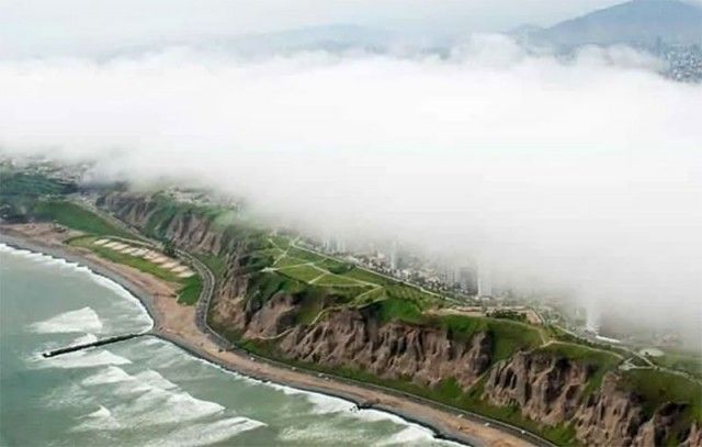
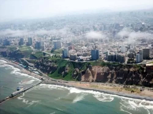
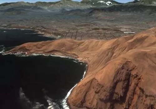
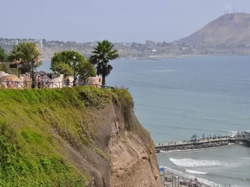
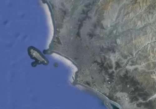
Lima, the capital of Peru, is located on the central coast of Peru on the south bank of the Rimac river. It is nestled between the Pacific Ocean and the foot of the western slope of the central Andes along the Peruvian coastal desert strip.
To make matters a bit confusing and information, data and statistics difficult to put into perspective, Lima is the name of four different areas. Therefore, right at the beginning, an explanation of the “four different Limas”.
- Provincia de Lima (Province of Lima): Today, when we talk about Lima, the city of Lima or the capital of Peru, we usually mean the Province of Lima, which was created on August 2, 1821, shortly after Peru’s independence. The Province of Lima is autonomous and does not belong to any of the 24 Peruvian regions, however, it has a special status equivalent to the one of a region. The Province of Lima is divided into 43 districts (distritos), one of them being the District of Lima. The Facts & Figures of Lima provided in this article refer, if not otherwise stated, to the Province of Lima.
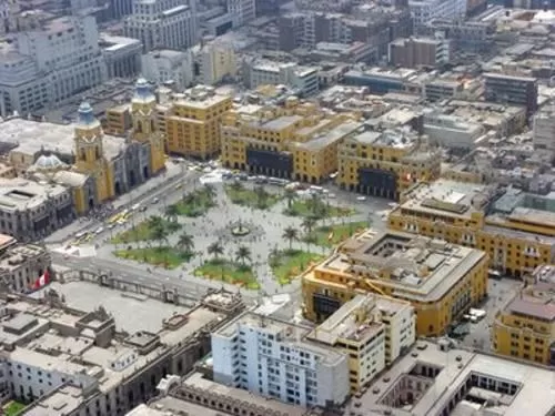
- Distrito de Lima (District of Lima or Lima city center): The district of Lima is one of the 43 districts of the Province of Lima which includes among other areas the historic city center, the place where Francisco Pizarro founded the new capital of the Viceroyalty of Peru in 1535.
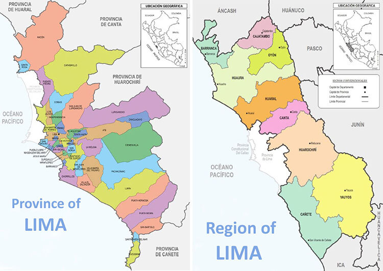
- Región de Lima (Region of Lima): The Region of Lima, which surrounds the Province of Lima to the north, east and south, is one of the 24 regions (departmentos) of Peru. It is divided into nine provinces: Barranca, Cajatambo, Canta, Cañete, Huaral, Huarochiri, Huaura, Oyón and Yauyos. The capital of the Region of Lima is Huacha. As the Province of Lima is autonomous, it is not part of the Region of Lima or any other of the Peruvian regions.
- Lima Metropolitana (Lima Metropolitan Area): The Lima Metropolitan Area comprises the autonomous Province of Lima and the Constitutional Province of Callao. Founded in 1537, just two years after the foundation of Lima, the city of Callao, back then “far away” (the distance from Lima’s city center to Callao city center is around 14 km (8 miles), was and still is Lima’s and Peru’s gateway to the world. Here you not only find Peru’s main seaside port but also Peru’s main airport, Jorge Chavez International Airport. Though both are autonomous provinces, over the past twenty year or so the two cities fused together to one huge metropolitan area, referred to Lima Metropolitana.
Lima is the largest city of Peru covering an area of 2,672 sqkm (1,032 square miles). The Peruvian capital is home to over 10 million people (projections from 2023; last census in 2017: 8.5 million), roughly a third of the Peruvian population. According to projections for 2023, 11.3 million people live in the Lima Metropolitan Area (last census 2017: 9.6 million).
In 2022, Lima was listed as 32nd largest city in the world and and was among the 30 most populous metropolitan areas in the world. Additional, the Peruvian capital is the 2nd largest capital in a desert (after Cairo).


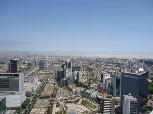
Lima is not only the largest city in Peru but also the political, economic and cultural center of the country. Here you find the good and beautiful as well as the bad and ugly and anything in between; the ancient, the old and the new; the loaded and the rich as well as the poor and the destitute; the luxury, the sumptuousness, and the extravagance as well as the austerity, the sorrow, and the misery; the chaos and the hectic as well as the peace and the tranquility.
The Peruvian capital accommodates the Peruvian President, the Peruvian government and the Peruvian congress as well as all Peruvian government authorities and institutions. It houses numerous national and international organizations, associations, cooperations and institutes as well as over 50 foreign embassies. Nearly all the larger Peruvian companies, businesses and commerces are located with their main branch in Lima. The best hospitals, schools and universities of the country are located in Lima.
Additionally, you find the remains of ancient civilizations, a wealth of museums, theaters, cultural centers and art galleries showcasing the country’s history, diverse culture and artisitc past, present and future. Throughout the year, Lima hosts various cultural events and festivals.
And last but not least, with Peruvian cuisine becoming known around the globe for being the most diverse and exciting in the world, Lima developed into a culinary destination over the past two decades. So, the Peruvian capital offers a wide range of restaurants, from street food stalls and local eateries to high-end dining establishments run by acclaimed chefs. Some restaurants in Lima were recognized as the best in the world. Additionally, the city hosts various gastronomic fairs and festivals that celebrate the country's culinary heritage, bringing together chefs, food enthusiasts, and visitors from all over the world.
2 Geography of the Province of Lima
Location of Lima:
- West central coast of Peru
- Located in a desert stripe between the Pacific Ocean to the west and the Andes mountains to the east
- Mostly on flat terrain off the Peruvian coastal plain
- Within the valleys of the Chillon, Rimac and Lurin rivers
- Historic city center is located at the shore of the Rimac river
Expansion of Lima:
- Area of 2,672 km² (1,032 square miles)
- Metropolitan Lima (comprising the Province of Lima and the Province of Callao) stretches from the north to the south along the Pacific Ocean for around 80 km (49.7 miles)
- Metropolitan Lima (comprising the Province of Lima and the Province of Callao) stretches west to east from the Pacific to the Andes for around 40 km (24.8 miles)


Major rivers in Lima:
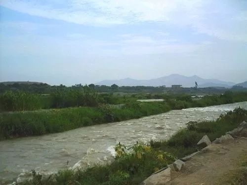
Río Rimac, Río Chillón and Río Lurin
Elevation extremes in Lima
The city of Lima gently rises from the shores of the Pacific Ocean to the foothills of the Andes mountains. The lowest point is the Pacific Ocean in the west. Lima's main square, about 10km (6miles) beeline inland to the east, is located at an altitude of 154m (505ft), Cerro San Cristobal at 400m (1300ft) and the district of Chaclacayo, over 40km inland to the east lies at an altitude of 650m (2,130ft).
Natural hazards in Peru
- Earthquakes
- Tsunamis
- Flooding
- Landslides
3 Climate & weather in Lima
Climate:
- Mild climate throughout the year, despite being in the tropics and in a desert
- Sunny, moist and warm summers
- Cloudy, humid, and mild winters
- Microclimates
Temperatures:
- December to May average daily temperatures range from 25°C to 32°C (77°F to 90°F)
- June to November average daily temperatures are between 12°C and 20°C (54°F to 68°F)
You find more detailed information in our article "The Weather and Climate in Lima"
The Weather and Climate in Lima
4 Local government & administrative divisions
Lima is not only the capital of Peru, but as well the capital of the Province of Lima. As the Province of Lima does not belong to any of the 24 Peruvian regions, it has a special status equivalent to the one of a region.
So, even though just being a province, the Municipality of Lima, headed by the Mayor of Lima, is the administrative and local government body of the Province of Lima, so of the entire city, and as well of the District of Lima. The Municipality of Lima and the Mayor of Lima act as and have similar functions as a regional government and its governor. The Mayor of Lima is elected by popular vote for a 4-year term, as is the supporting provincial Council of Lima.
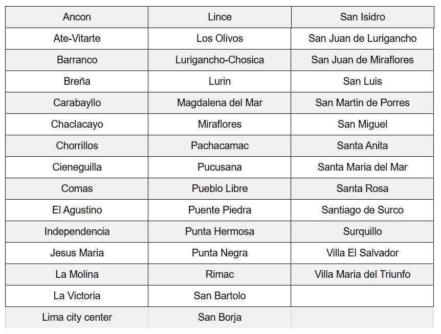
The districts of Lima
The Province of Lima, so the city, is divided into 43 districts, each with a unique character and different demographics. Each district has its own local government and mayor. The districts in alphabetical order are:
And here a map of Lima with the districts

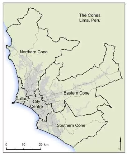
Lima's cones ("subregions" or in Spanish conos)
To better support and develop the different demographic areas in Lima, the city is additionally divided into "subregions", formerly known as Conos (cones).
Be aware that especially the division of Lima Centro, Lima Residencial, Lima Moderna and Lima Oeste seems to vary depending on the official source and year.
- Lima Norte: North Lima comprises the districts of Ancon, Carabayllo, Comas, Independencia, Los Olivos, Puente Piedra, San Martin de Porres and Santa Rosa.
- Lima Este: East Lima comprises the districts of of Ate-Vitarte, Chaclacayo, Cieneguilla, El Agustino, Lurigancho-Chosica, La Molina, San San Juan de Luriganco and Santa Anita.
- Lima Centro: Central Lima comprises the districts of Breña, La Victoria, Lima (downtown), Rimac and San Luis.
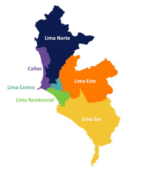
- Lima Residencial, also known as Lima Moderna or Lima Oeste: Residential Lima (Modern Lima or West Lima) comprises the districts of Barranco, Jesus Maria, Lince, Magdalena del Mar, Miraflores, Pueblo Libre, San Borja, San Isidro, San Miguel, Santiago de Surco and Surquillo.
- Lima Sur: South Lima comprises the districts of Chorrillos, Lurin, Pachacamac, Pucusana, Punta Hermosa, Punta Negra, San Bartolo, San Juan de Miraflores, Santa Maria del Mar, Villa el Salvador and Villa Maria del Triunfo.
- Callao: Callao, even though an independent province, belongs to the Lima Metropolitan Area and comprises of the districts of Bellavista, Callao (downtown), Carmen de la Legua Reynoso, La Perla, La Punta, Ventanilla and Mi Peru.
5 Lima's official symbols
Flag of Lima
The flag of Lima, historically know as the "Standard of the City of the Kings of Peru" (Estandarte de la Cuidad de Reyes del Peru) is designed on a golden (yellow) background, supposedly symbolizing the natural resources and the rich historical and cultural heritage of the area. In the center, Lima’s coat of arms, which was granted to the city in December 1537 by the Spanish Crown, is placed.
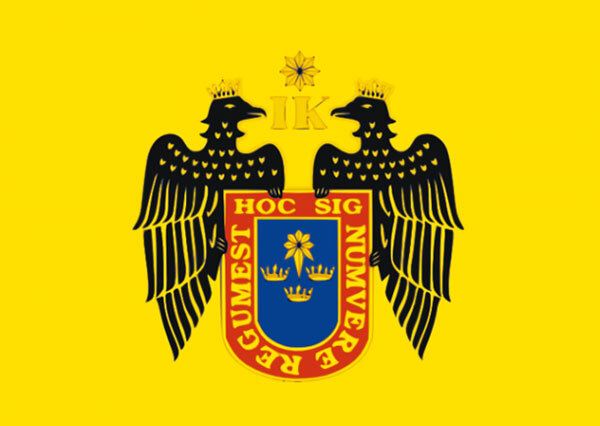
Lima's Coat of arms
On December 7, 1537, the Spanish King Charles V and his mother, Queen Joana of Castile, granted Lima its own coat of arms.
At the top of the Lima’s coat of arms in the middle is a golden star, which symbolizes the protection of the shield (and therefore of the city) by the Spanish Crown. Below are the initials I and K, which represent the names of Queen Joana and her son King Charles V (Ioana y Karolus). To the sides, two crowned black eagles, representing the Catholic kings, firmly hold the shield, symbolizing the protection of the city by the Spanish Crown.
The red border of the shield is decorated with the golden inscription in Latin “Hoc signum vere regum es” (This is the true sign of the kings). In the blue middle, which symbolizes loyalty to the Spanish Crown, are three golden crowns, which were intended by Francisco Pizarro, the founder of Lima, who designed the coat of arms himself, to honor the kings of Spain, and an eight-pointed golden star with tail symbolizing the guidance of the Spanish Crown. As Lima was founded near the date of Epiphany, the three crowns and the star as well have a religious meaning, with the crowns representing the three Magi and the star guiding them to Jesus.
Lima's Anthem
Since 2010, Lima has its own official anthem. Euding Maeshiro Nomura is the composer of the melody, Luis Enrique Tord Romero the author of the lyrics, and Ricardo Nuñez produced the anthem.
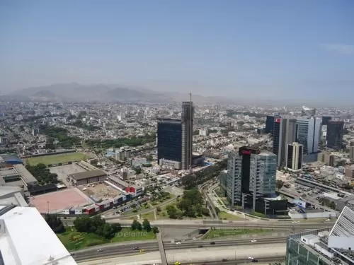
6 Economy of Lima
Lima plays a crucial role in the Peruvian economy. The Peruvian capital is the industrial, commercial, and financial center of the country and generated 45% of Peru’s national GDP and nearly 60% of Peru’s industrial GDP in 2022.
Industry and manufacturing
As the major economic center of the country, Lima attracted and still attracts both domestic and foreign investments, resulting in the establishment of various industrial and manufacturing companies.
More than two-thirds of Peru’s industrial production takes place in the Lima Metropolitan Area in around 7,000 factories. Primary products are textiles, clothing and food. Chemicals, fish products, leather, paper, and oil derivatives are also manufactured or processed in Lima.
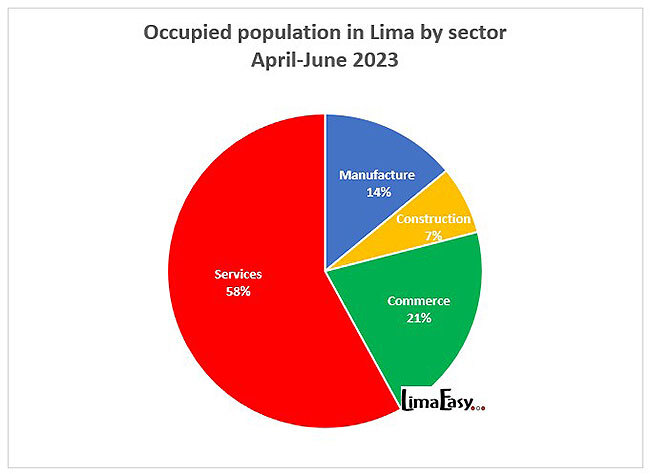
Services
The service sector in Lima is diverse, employing 58% (Apr-Jun 2023) of the occupied population in the Peruvian capital. The sector includes telecommunications and finance services, accommodation, restaurants and tourism, trade, and other services such as education, health, and real estate activities. Opening up to new technologies, especially over the past years, digitalization slowly helps to create new and improve existing services in Lima.


Financial center
Lima’s financial center is the district of San Isidro. Here you find the headquarters of banks and insurance companies, the offices of various companies and national and international organizations, several Peruvian ministries, most of the foreign embassies in Peru, the famous Lima Country Club and first class hotels aiming at business travellers and well off visitors.
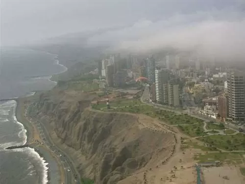
Tourism
Even though still seen as an unavoidable must on the way to other exiting destinations in Peru, over the past decade or two Lima became a destination for itself. With its rich archaeological, cultural and historical past, the Peruvian capital has a lot to offer.
Stunning archaeological sites, uncountable museums, amazing historical buildings, great festivals, fairs and other events throughout the year, beautiful parks, and the best of Peru's gastronomy combined with the international airport, affordable taxi services, countless hotels in all categories, lots of travel agencies and tour operators, nice shopping facilities and additonally other lovely attractions just an hour or two away make a visit worthwhile.
Port and airport
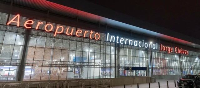
The Lima Metropolitan Area as well has the largest export industry in South America and is a hub for the cargo industry. Here, the seaport of Callao, which not only is Peru’s major port but also one of the main fishing and commercial ports in South America, plays an important role. Additionally, Jorge Chavez International Airport, located as well in Callao, undergoes expansion at the moment, which among other features includes the development of an Airport City, the first in South America strengthening Lima’s position as a commerical and transport hub in the region.
Labor and employment April-June 2023 (source: INEI)
- Working age population: 8.45 million
- Economically active population of Lima: 5.58 million
- Adequate employment rate in Lima: 53.8%
- Underemployment rate in Lima: 39.7%
- underemployed by hours. 7.8%
- underemployed by income: 31.9%
- Unemployment rate in Lima: 6.6%
- Formal employment: 41.8%
- Informal employment: 58.2%
- Informal businesses: 35.9% of the businesses in Lima are informal
- Minimum wage in Peru since May 2022: S/ 1025 per month
- Average monthly income in Lima: S/ 1,924.70
Poverty in Lima (source: INEI 2022)
- 26.5% of Lima's population lives in poverty
- 2% of Lima's population lives in extreme poverty
7 People of Lima
Population of Lima (source INEI):
- Population of the city of Lima (43 districts):
- 2023 (projection): 10,148,810
- 2017 (Census): 8,857,974
- Population of the Lima Metropolitan Area (43 districts of Lima and 7 districts of Callao):
- 2023 (projection): 11,339,314
- 2017 (Census): 9,569,468
- Population density: around 3,200 people/km2 (nearly 8300 people/square mile)
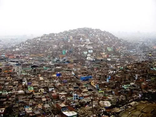
- About a third of Lima's population lives in squatter settlements called "pueblos jovenes" (young towns) or "barriadas" (shantytowns)

You can find more detailed information about the population development in Lima including exact numbers about the population distribution by district in our article "Population Development in Lima".
Population Development in Lima
Population distribution by "subregions" in the Lima Metropolitan Area:
- 26% (2022) of the population lives in Lima Norte (North Lima); 36.6% (according to the Census 2017)
- 25% of the population lives in Lima Este (East Lima); 14.3% (according to the Census 2017)
- 18% of the population lives in Lima Sur (South Lima); 17.8% (according to the Census 2017)
- 7% of the population lives in Lima Centro (Central Lima) comprising the districts of Breña, La Victoria, Lima downtown and Rimac; 7.3% (according to the Census 2017)
- 14% of the population lives in Lima Residencial (Residential Lima); 13.6% (according to the Census 2017)
- 10% of the population lives in Callao; 10.4% (according to the Census 2017)
Age distribution in Lima 2022 (source: INEI)
0-14 years: 18.6%
15-59 years: 64.9%
60+ years: 16.5%
Ethnic groups in Lima (source: INEI; National household survey 2022)
- 65.1% of the population of Lima considers themselves Mestizo (mixed European and indigenous Indians)
- 18.9% of the population of Lima considers themselves Nativo (Quechua, Aymara, Amazonian native)
- 4.7% of the population of Lima considers themselves White
- 4.1% of the population of Lima considers themselves Afroperuvian
- 4.2% of the population of Lima considers themselves belonging to another ethnic group
- 3% of the population of Lima didn't know


First language learned by children in Lima (source: INEI; data from census 2017)
- Spanish (official language): 90.71% of Lima's population (in Peru by 82.6)
- Quechua (official language): 8.15% of Lima's population (in Peru by 13.9%)
- Aymara (official language): 0.38% of Lima's population (in Peru by 0.7%)
- Foreign language: 0.4% of Lima's population (in Peru by 0.2%)
Demonym
People living in Lima are called Limeño (m) or Limeña (f).
8 Education in Lima
Lima has with 97.9% the highest literacy rate in Peru. Only 2.1% of the population age 15 and older cannot read and write.
Parents in Lima have the choice between costly private national and international schools or government funded public schools, which drastically lack resources.
In Lima
- 1.3% of the adult population older than 15 years has no formal education
- 10.7% of the adult population has a primary education
- 48.9% of the adult population has a secondary education
- 16.7% of the adult population has a tertiary education (no university)
- 22.6% of the adult population has a university education
You can find more information about schooling in Lima and Peru in our article "International Schools in Peru".

Universities in Lima:
Lima is home to many recognized public and private universities. The oldest university in the Americas, the Universidad Nacional Mayor de San Marcos UNMSM (National University of San Marcos), founded in 1551 is located in Lima.
Other top universities include:
- Pontificia Universidad Católica del Perú PUCP - The Pontifical Catholic University of Peru
- Universidad Peruana Cayetano Heredia UPCH - Cayetano Heredia University
- Universidad de Lima - University of Lima
- Universidad Nacional Agraria la Molina UNALM - La Molina National Agrarian University
- Universidad Nacional de Ingeniería Peru UNI - National University of Engineering
- Universidad del Pacifico UP - University of the Pacific
- Universidad Peruana de Ciencias Aplicadas UPC - Peruvian University of Applied Sciences
- Universidad de San Martín de Porres USMP - University of San Martín de Porres
You can find more information about higher education in Lima and Peru in our article "Top Universities in Peru".
9 Transport and infrastructure in Lima
Airports in Lima
- Jorge Chavez International Airport in Callao
- Las Palmas Air Base (military airport in Surco, Lima)
Port in Lima
- Seaport of Callao; located around 15 km (less than 10 miles) west of Lima's city center. It was founded in 1537 by Francisco Pizarro and since then is Lima's gateway to the world, where the majority of imports and exports move through.
Train in Lima
- Desamparados Train Station in Lima's city center; however, only one public train leaves Lima more or less regularly for a trip on the world's highest railway from Lima to Huancayo.
Main Roads from and to Lima
- Pan American Highway (Pan Americana) runs from north to south along the coast
- Central Highway (Carretera Central) runs from east to west and connects Lima with the Peruvian highlands
Public Transport in Lima
- No proper city wide system of public transportation
- Main public transport is organized by tens of thousands of poorly maintained small buses and around 200,000 taxis
- Metropolitano: In June 2010 the first route of Lima's new public transportation system, called the Metropolitano was inaugurated; gas buses that drive on a newly build highway, called Ruta troncal, with a fancy underground bus station in Lima's City Center running from Chorrillos in the south to Carabayllo in the north. Next to this main route several "feeder" routes (Rutas alimentadora) bring passengers to the main route. More routes are in palnning.
- Lima's Metro / Tren Electrico: Another ambitious project is an above ground electric mass transit system, the Tren Electrico (electric train) or Lima's Metro. Planned and started to build in the 1980s, the project lay idle for over two decades. Finally, trains started running in December 2011 on Route 1 from Villa El Salvador in the south of Lima to San Juan de Lurigancho in the north. The second route connecting Ate, the city center and Callao (airport and port) is in construction.
10 Major problems of Lima
- Urban growth: The rapid population growth, especially in the second half of the 20th century, has led to uncontrolled urban development, urban sprawl and the expansion of the city into surrounding areas. As Lima is located in a valley, bounded on the west by the Pacific Ocean, on the east by the Andes, the space for the city expansion is limited.
- Informal settlements: Lima has a significant number of citizens living in informal settlements or shantytowns, where people settled on the land before it even had been developed. These informal developments lack proper infrastructure and access to basic services.
- Administrative divisions: The division of Lima into 43 separate districts, each with its own mayor, municipality, interests, and financial means, makes the development, financing, and implementation of cross-district or even city-wide projects extremely difficult.
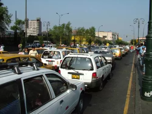
- Traffic and mobility infrastructure: Lima is notorious for its immense traffic. Having no proper city-wide public mass transportation system, the city’s road infrastructure struggles to keep up with the rapid urbanization, a growing population that needs to move and an increasing number of vehicles on the streets.
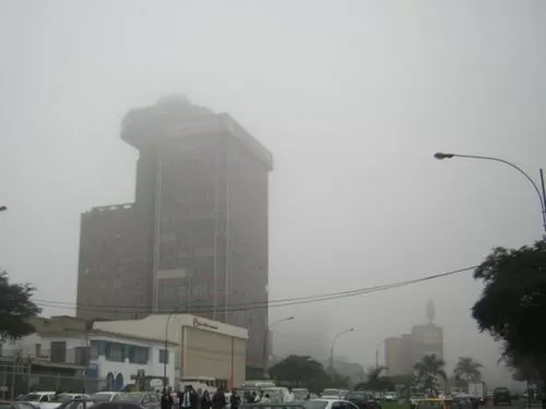
- Air pollution: The combination of immense traffic, industrial activities, geographical factors, and the unique climate in Lima contribute to high levels of air pollution.
- Waste: In Lima, about 9,000 tons of garbage is generated daily. Only more or less 4% is recycled and only 53% of the solid waste reaches one of the only four sanitary landfills. The rest ends up in one of the 19 registered dumpsites, which are near residential and agricultural areas, in countless illegal dumps, on the street, in the rivers or the ocean.
- Water scarcity: Lima is located in a desert region and hardly ever sees any real rain. The city’s water supply relies on the water from the Rimac, Chillon and Lurin rivers, which are fed by Andean glaciers, and on underground aquifers.
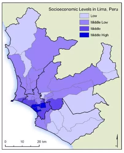
- Social inequality: The Peruvian capital experiences significant social disparities. While some areas and a part of the population enjoy great opportunities, a good infrastructure and a high living standard, other parts of the city and their residents struggle with poverty, lack access to basic services and infrastructure, and don’t have opportunities.
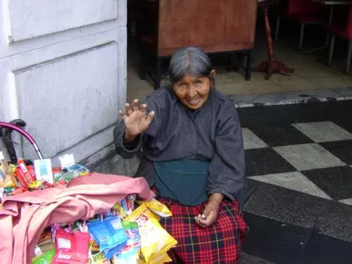
- Informal employment / underemployment: Nearly 40% of Lima’s businesses are informal, and over 58% of the occupied population of Lima works in the informal sector; meaning the businesses aren’t registered and not regulated and don’t pay taxes, workers don’t have access to social security and lack other labor protections. Additionally, about 40% of Lima’s occupied population is underemployed; from these, over 80% by income.
- Crime: Lima has, like many other megacities where rich and poor live closely together, areas with higher crime rates. Theft, robbery, burglary and petty crime are common, drug/cartel related crimes on the increase. Maintaining public safety and security in some parts of the city is a challenge.
- Corruption: As everywhere in Peru, bribery and corruption are omnipresent in Lima, undermining trust in state institutions, hindering economic growth, diverting resources away from essential services and infrastructure, and increasing inequality.
Facts & Figures of Peru
For detailed numbers, data, and stats, as well as lots of useful information about Peru check out our extensive "Important Facts and Figures about Peru"


")


")


")


